After a trip to the restroom I talked to another guy staying in the campground. Turns out he is a tree planter working at the coal mine south of the forest. Along with his crew, he walks the landscape carrying saplings to plant. He described the work as “almost athletic”, carrying heavy backpacks of trees across steep terrain.
Breakfast before packing back into the truck.
With coffee and cereal consumed we packed up and pulled out of the campground. The tree planter told me about a short cut to US77 that involved a winding dirt road through the southern end of the state forest. He was right, it was a shortcut and it was certainly winding as well.
About four hours after leaving the campground we were driving west on 422, following the signs to Boone. The mountains began to appear on the horizon and we began to talk about the upcoming rides we would do.
Mountains growing as we approach Boone.
Boone greeted us with road construction and road confusion. I was surprised at the amount of traffic, maybe it was the tail end of lunch hour. After a couple wrong turns and scrutinizing my printed Google maps we found Poplar Grove Rd. and twisted our way to the Honeybear Campground.
On our second attempt at a campsite we found a suitable site. My only complaint about the campground was how closely together the sites were situated. From one gravel parking pad to the next was a single step away. Fortunately their were only about four occupied sites in the whole campground, we setup our camp and became the fifth.
The skies were a little overcast and the temperature was in the mid 50’s. We donned our OCC wool sweaters and knee warmers to head out on a ride.
Pedaling on the Blue Ridge Parkway.
From the campground to the Blue Ridge Parkway is a 6 to 8 mile ride and there are a couple moderate climbs along the way. We were good and warmed up by the time we reached the Parkway. The destination for the ride was the Linn Cove Viaduct to the south. It’s a prominent concrete bridge on the shoulder of Grandfather Mountain.
Approaching Grandfather Mountain.
Near the entrance to the Parkway we noticed a cyclist stopped alongside the road. At first I thought he was having mechanical problems but as we rode closer I realized he was just chillin’ for a moment. I also realized he was wearing a Bissell kit and riding what looked to be a team issue Pinarello race bike. Eric, as it turns out, is a rider for the Bissell development team and his team has been training in the Boone area for the past five days. He gave us some good information about the area, including showing us a map purchased from a gas station that is helpful for getting around the area on a bike.Together with Eric we hopped on the Parkway and began heading south. After several miles of chatting and riding Eric turned around to continue his ride. Ryan and I climbed on the Parkway to reach the Viaduct, stopping a couple times along the way to take pictures with the beautiful mountain scenery. After crossing the Viaduct we turned around and enjoyed some fast downhill riding back to where we entered the parkway.
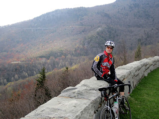
Ryan sporting OCC colors on the Parkway.
(The Viaduct is in the upper left.)
(The Viaduct is in the upper left.)
KOM bike, appropriately placed.
Back at the campground we finished setting up our camp and began to think about dinner. After nice, hot showers we fired up the Coleman stove to heat some white chicken chilli that Ryan’s wife made for us. It was very good, eaten from a bread bowl.
I talked to Katie on the phone and learned the weather forecast was not looking good at all. Tomorrow should be good but showers and storms are forecasted for the following days. Apparently the radar map was showing a large system centered over the country that was due to move our way in another day.
With the new weather information in mind we looked through the guidebook for a good route to do tomorrow. We are going to fall asleep thinking about a climb up Snake Mountain and a section described in the guide book as “cry to your mama steep.”


No comments:
Post a Comment