Showing posts with label mountain bike. Show all posts

Saturday, October 10, 2015

Mohican Morning

Ryan and I made it down to Mohican first thing in the morning and got in a nice ride.  It was a little chilly when we started but we warmed up quickly.  I always enjoy an early morning ride with the light and trees in the woods.

About 45 degrees when we started.  Always
thankful for the first uphill mile on
cooler morning.

Light show!


Monday, September 7, 2015

Pisgah MTB Trip Report - 3 of 5

With some Pisgah National Forest riding under our belts we decided to turn our attention to Dupont State Forest today.  Equipped with some trail suggestions from Brian at the Bike Farm we drove about 30 minutes to the Buck Forest parking lot.

Bikes ready to go.

Part of the enjoyment in being on a guys bike trip is to not have a schedule and the ability to take our time as we care.  So, we setup our camp chairs behind the car in the parking lot and took our good ol' time eating some food and getting ready to ride.  As we were hanging out, a vehicle pulled in and it was the couple from out west we had met the day before.  It was a little unexpected to see them again.

Slick rock!

Eventually we rolled out and rode Corn Mill Shoals Trail to do a clockwise loop of Burnt Mountain.  It was a good little climb up and a fast ride down!  We then rode the Little River Trail to Cedar Rock Trail and got our first taste of Dupont slick rock.

A cairn to show the way.

Slick rock riding is typically thought to be out west, in Moab, UT for example, but Dupont is one place in the eastern US where you can ride slick rock trails.  Despite the name, slick rock offers lots of traction and allows you to ride up steeper than normal gradients.  The slick rock trails we rode were not particularly steep but it was a fun experience.

Topping out.

We spent some time taking pictures and eating atop Big Rock.  The views were nice but seemed distant due to the large, flat area atop this mountain.  A few other mountain bikers passed by as well as some hikers.  A group of about five young boys mountain biking with a couple adults came riding up as we were headed down the Big Rock Trail.  It was good to see some young blood cranking it up.

An expansive summit.

Within a few minutes we rounded a corner and found an impressive view to the north.  Hey, we are on vacation with no schedule so we stopped again for some pictures.

 More pictures.

The ride back down to Corn Mill Shoals was a fast one.  There was plenty of downhill excitement with corners and drops.  It was quite fun and we headed back to the car having enjoyed our first several trails of the day.

 One of the Dupont locals.

Once again we setup camp chairs behind our car in the parking lot and relaxed while eating.  We studied the map and made a plan for an afternoon ride to see the airstrip as well Bridal Veil Falls.  Back out Corn Mill Shoals and then we rode the Shoal Trail and Laurel Ridge Trail to work our way over to Airstrip.

 Check out the Klein!

There was an interesting water crossing along the way.  We came to a crowd of ten to twelve people at the crossing.  Some were going one way and some the other, but everybody was walking and not riding across the stream.  Turns out the rocky bottom was very slippery with signs warning to dismount.

 Slickrock is indeed slick when under water and slimey.

There is an interesting history to the park.  Its name comes from the DuPont corporation and the area was once a getaway for employees, complete with an airstrip for flying in / out.  Obviously it's now a state park bu the airstrip is still there.  We rode right down the middle of it with arms held horizontally, air plane style.

A nice view to the northwest at the end of Airstrip.

Distant mountains beneath the clouds.

The Briery Fork Trail dropped us down from the airstrip with several big berms and switchbacks.  We descended in a hurry and rode over to Bridal Veil Falls.

Bridal Veil Falls

It didn't seem like there was match water falling at the water fall.  It was impressive to see the expanse of rock from below, but we had to ride up it.  Good thing we did as there were several pitches to the falls.

Some interesting bowls and puddles. 

Halfway up.

At one point it seemed like a storm was going to blow in but it never became more serious than a few sprinkles.  At the top most point of the falls was a nice spillover.  We walked around the side and behind the water.  A head rinsing was refreshing with the cold water.

 The top falls.

For the second time today we rode Corn Mill Shoals back to car. The stream crossing was in play again on the ride back.  It had been a great day of riding at Dupont.

In Brevard we stopped at Sycamore Cycles to check things out and got a good tip for a Mexican restuarant for dinner.  I ordered some sort of sampler and ended up with what seemed like two dinners.  This worked out well to replenish some calories spent today.

Refuel!

Back at camp we setup our folding cots in lounge chair configuration and relaxed until after dark.  The insects were again surrounding us in full symphony, but I had no problem falling asleep tonight.

Katydid in love with the lantern.

Sunday, September 6, 2015

Pisgah MTB Trip Report - 2 of 5

Good morning wet campground, from inside a dry tent!  That's a good way to wake up this morning.

In the middle of the night I awoke to the sound of approaching rain in the forest.  Wait for it... rain drops smacking the canopy came next.  Last I remember using the canopy in the rain was on a past bike trip and I recall the seams were not water tight.  Wait for it... water drops smacking the fly of the tent came next.  That's as low as the water came in our sleeping quarters, so all good for us.

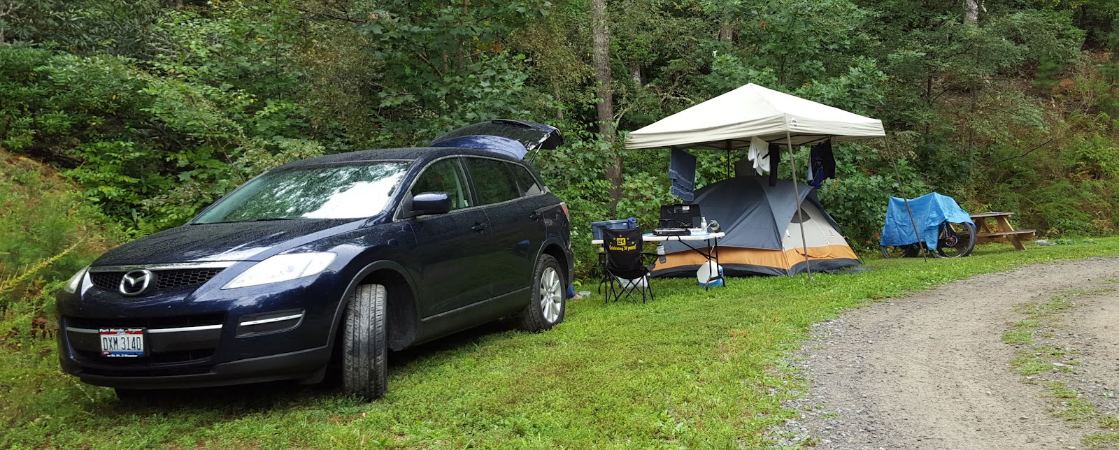
Camping on the corner.

Our bikes stayed mostly dry leaned against a picnic table, covered with a blue tarp.  After some breakfast we pulled the tarp and did some bike maintenance to prepare for today's riding.

Last night we talked to Brian, the Bike Farm Pisgah guide, about how necessary a "dual squish" bike is in Pisgah.  After asking about our riding experience, he concluded we should give our hard tails a try.  We could always rent full suspension bikes for subsequent rides if need be.

Getting them ready to roll.

Back down the steep gravel driveway and we headed south to Brevard.  A turn west onto 276 took us into Pisgah National Forest.  Just like our mountain bike guidebook said, it's a sudden shock to go from the shopping plazas of Brevard to the expansive wilderness of the forest.

Pisgah welcome.

About five miles into the forest we turned onto a forest service road and continued past a fish hatchery another several miles to a parking area for the Daniel Ridge Trail.  There were a dozen or so cars in the lot as we geared up to ride a loop.

As we crossed a bridge, stayed left, and started onto the trail it was easy to spot multiple tents and camp setups along the river. I'm guessing many of the cars in the parking lot were people primitive camping on the holiday weekend.  It looked like there were many suitable spots.

Starting the up on Daniel Ridge Trail.

About a mile in we reached the start of the uphill.  Wow, the fun begins!  It was pretty steep, rooty, and rocky.  I took several tries to clean the opening section but was only able to go so far before getting stumped.  We would ride as much as we could before getting hung up.  I remember one prominent two foot tall rock ledge during the uphill that was not rideable.  For a third of a mile we were sucking wind while trying to ride it.

Just past the intersection with Farlow Gap.

The trail topped out at an intersection with Farlow Gap and we turned right.  Along this section of trail we encountered several riders coming towards us, including a teenage girl with her dad.  She was hitting it pretty hard as we gave her the right away on a short downhill!

It was still rocky but very rideable for another mile.  We stopped at a crossing with a logging road, just before a good downhill, and spotted two riders coming up. Hmmm, that makes five people going the opposite way as us.

The two riders stopped to chat.  They were a husband and wife from out west on a several week road trip to the east.  We enjoyed their descriptions of places to ride in Colorado and Utah, and we took note of a couple destinations should a trip west ever workout for us.

Waterfall with limited water.

Next up, some downhill for the next 3/4 mile.  There were a few surprises but it was all fast and rideable.  Sure, suspension out back could have allowed more reckless attacking on the downhill, but we still got the job done on our bikes.

The guidebook said to listen to the left for a waterfall at the bottom of the downhill.  Not much waterfall sound today as the water was sparse, but we stopped anyhow to check it out.

Someone has been playing in the creek.

Back at the parking lot we were greeted by twice as many cars as when we left.  We did seize the opportunity to move our car from a sunny to shaded spot and enjoyed tailgate snacking.  Many families were out for the day to hike to the waterfall or play in the stream.  We consulted the guidebook for our next adventure and found Butter Gap to be a good option.

From the parking lot we rode west on gravel forest service road 475 and began to climb.  It was uphill but not too steep.  A few miles later we turned left onto FSR 471 and continued uphill another couple miles.  With no other cars or people around and nothing but the forest in all directions it was feeling remote.

Eventually we came upon a parking pulloff with a couple vehicles and made our left turn into the woods.  Passing a gate and heading uphill it narrowed down to a trail.  At a 7-way intersection we turned onto Butter Gap Trail and locked in some downhill smiles.

Rhododendron tunnel on Buter Gap.

A well-marked intersection appeared and we consulted the map.  It looked like we had two options to get back to our start.  Suddenly a couple of hikers appeared from down trail. We learned from them the Butter Gap trail from this point north was not open to bikes this time of year.  This new found information made our decision obvious and we turned left onto Long Branch Trail.

Direction check.

Long Branch had some interesting terrain complete with drainage gully climbing and a stream crossing or two.  We rode it back to FS475 and tucked in to fly down hill on the gravel road.  It was a blur going down and we were back to the car in a hurry.

Stream crossing complete with
log bridge and hand rail.

It was late afternoon and the Labor Day forest visitors joined us in heading back to town.  We sat in no moving and slow moving traffic heading to Brevard.  Hunger and the GPS led us to the Oskar Blues Brewery for food and drink, the one in North Carolina not the one in Colorado.

Welcome to Oskar Blues.

Oskar Blues is quite involved in the bike world, especially in Pisgah.  Their Reeb Ranch is another option for camping and lodging in nearby Hendersonville.  We didn't get to go on a brewery tour, but we walked into the facility to pickup our beer and spotted a full lineup of bikes next to the brew tanks.

Flight of beer in a plank and a burger.

Full of Chuburgers and beer we returned to the Bike Farm for the night.  The outdoor shower once again cranked out some really hot water.  Then we visited with Bike Farm guide Brian and discussed options for riding at Dupont State Forest tomorrow.

We told of our riding today and learned the Daniel Ridge Loop is typically ridden the opposite direction as we had done.  Well that explains why everyone else was coming towards us.  Apparently the challenging uphill we did is a much enjoyed downhill.  Even so, we had our fun!

Stickery.

Saturday, September 5, 2015

Pisgah MTB Trip Report - 1 of 5

In a last minute kind of way Ryan and I made plans for Labor Day weekend road trip to mountain bike and camp.  We had been considering a trip all year but never put a date on the calendar.  Thankfully our family and work schedules cooperated to make a trip come together... but where to go?

The Pisgah National Forest area has been on our radar for some time.  I did some riding in this area of western North Carolina several years ago and have wanted to go back ever since.  With the ability to get away for multiple days we decided to go for it and head ~8.5 hours south.

Riding at Bent Creek!

Saturday morning and time to head out!  We loaded up the CX9 and left Ryan's house at 06:30.  With the rear seats down there was plenty of space for all our camping gear.  The bikes followed along on the hitch rack.  Thankfully, the weather forecast looked good for the next five days, and we made good time driving beneath sunny skies.

A couple days prior to leaving I checked the public campgrounds in the Pisgah area and found they were all booked full, certainly due to Labor Day weekend.  Fortunately I had heard about Bike Farm Pisgah and their web site indicated they had open car camping sites.  Perfect!  I booked a site online.

We made it to Asheville about 15:00 and decided to stop at Bent Creek Experimental Forest for an afternoon ride before heading to camp.  The Rice Pinnaccle parking lot was nearly full as we geared up and rolled out.  I wanted to ride the Green's Lick downhill again, so we worked our way up Wolf Branch and Ledford trails to the ridge on the northern side of the area.  Sustained climbing and warm temperatures tested our legs that had been sitting in a car all day.

Look out below!

Before long we were at the top of Green's Lick and ready for the downhill.  Just as I rememberd, it was fast and fun!  Lots of twists, curves, and jumps came at high speed.  We ripped it as best we could and reached the bottom with big grins.

Knowing there was still camp to find and setup, we headed back to the car but were lured off the road for more singletrack.  We rode service road 479E, blew past the turn onto Deer Lake Lodge, and ended up coming back down Wolf Branch.  Somewhere along the way a trail runner told us of a bear she had just seen.  We rode along scanning the woods but didn't see any bear, not today.

Back at the car we talked to a couple locals who seemed surprised to hear we woke up this morning in Ohio.  They asked about our plans for the rest of our trip and gave us strong recommendations to rent a couple "dual squish" bikes for Pisgah.  "Those hard tails are weapons here, but you are gonna need some 6-6 dual squish in Pisgah."

It was only about 30 minutes to drive from Bent Creek to Bike Farm Pisgah.  We spotted the sign on the west side of 280 and slowly drove up the private drive.  After filling out a waiver at the gate, we drove up and up a steep gravel road and were delivered to a clearing where a guide greeted us.

Brian from the Bike Farm explained the setup, pointing out the outdoor shower stall, water spigot, and directed us further up the hill to our car camping site.  He was very friendly and said to let him know if we had any questions about where to ride.

Car camping site #4.

Upon reaching our camp area, literally right next to the gravel drive, we were initially unsure about the not-so-level area.  Turns out my blindly picking car camping site 4 on the web site resulted in the least flat of the six sites.  They also had deck camping sites, for sure flat, but it would have been a little more work hauling our stuff down a sorta steep trail from where the car would be parked.  We settled in to our site and found it to be fine.

There was a likelihood of rain overnight.  Better at night than during the day, and the forecast for the next several days was clear.  We brought the canopy on this trip, it had been left behind on previous trips due to not enough vehicle room to haul it, and decided to set the tent under the canopy.

After dinner we studied our maps and guidebook for the area, making plans for our first Pisgah NF ride tomorrow.  The sun began to set and it was dark in a hurry.  Katydids, crickets, and I don't know what other kinds of insects were in full swing as we crashed for the night.  I didn't hear them for long.

Ryan fights KT's camping can opener...
eventually we ate some beans with our beef and rice.

Tuesday, April 21, 2015

OMBC Race Photo

During the race Saturday I remember seeing a photographer in the first rock on the state park loop.  As I rode by I thought a couple things:

1. I wonder if and where I may find his pictures online after the race?

2. I wonder how stupid of a face I could have been making as I passed by him and heard the camera snapping.

Fortunately, I easily found Butch Phillips Photography from the OMBC web site.  Even more fortunately, I didn't look too odd in the picture he posted of me. :-)

Racing.

Monday, April 20, 2015

OMBC Mohican Race Report

It's a first for me.  I've never done an OMBC race but decided to give it a go at Mohican, the second race of this year's series.  So far this year I have ridden at Mohican exactly zero times and only been on a mountain bike twice, for about 3 total laps at the Knob.  But on the positive side, I've been consistent on OCC rides and have felt pretty good. Trail riding, however, is a lot different than the road.

Trusty steed, except all those dropped chains.

Ten minutes after noon, when the expert riders rolled out, I lined up at the start line with the sport riders.  We were in for a full lap plus the trails/roads to get us to from the Mohican Adventures start line.  Shortly after leaving the start line we hit a gravel, steep uphill piece of singletrack and the bunch clogged up.  Off the bike and pushing but we were going again shortly.

Though I didn't want to go out too hard I think I may have.  I was passing riders in the first five miles only to later be passed by them.  Maybe do that different next time.  At the start line I had eaten two thirds of a Cliff Bar and I finished eating that five or six miles in.  On the downhills to the covered bridge I was feeling bold and was flying along pretty good.  I passed a couple guys on the downhill.

Crossing the covered bridge I sucked down half a GU and then started the climb. Maybe it was the aggressive downhill, but I didn't feel able to attack the climb like normal.  More likely, it's a lack of trail riding.  I felt like I really had to monitor my pace not to pop.

Coming into Trailhead B I felt pretty decent thanks to keeping it in check up the climb.  I refilled a bottle with some ice cold water.  It was the warmest day of the year so far and I was feeling it a little. I poured a bottle down my back and it took my breath away.  A handful of dried apricots and cashews gave me some good flavors.

From Trailhead B to the mile 19 crossing I was going pretty good. Unfortunately I dropped my chain about the second or third time of the day.  Something's up with my drivetrain as my 1x10 was doing quite well last year.  The Type 2 rear derailleur was doing it's thing but not today.  I dropped the chain at least four times.  The cost me five or so minutes I suppose, but I didn't get too rattled by it.

After mile 19 road crossing I sucked down another half GU and kept it truckin' best I could.  I felt like I was either going really fast or really slow, depending on terrain.  My bike handling was pretty good today.  I was keeping off the brakes and cornering well.  Some of the hills bogged me down a little.

Coming down to the campground I let a guy pass me just before a switchback only to see him crash right in front of me.  I cornered through on the inside line and he said "I'll follow you, I've never ridden here before."  Yeah, good idea.

As we crossed the bridge to campground my chain dropped again and rode away.  That one sucked as I would have liked to push to the finish with him.  After the section of trail along the campground I popped out at the start of the State Park loop.  Hmmm... I really had no idea how the race finished from here, but soon found out.

We went part way up the opening climb before branching off to the Mohican Adventure property.  There was a super punchy exit I was not at all prepared for and ended up hike-a-biking with several other guys.  Then there were a bunch of gravel roads, a sharp right I missed and had to circle back for, and some other varied gravel campground roads.  There was more racing in the campgrounds than what I expected but now I know.

I cranked down a gravel road to the finish line and crossed 2:40:XX after starting.  Cool!  My goal was to be less than 3 hours and I thought 2:45 would be a good challenge, though I had no idea how much the additional trail beyond the State Park loop would add.  I was mostly pleased with my effort and it was a perfect day for a mountain bike race!

Sunday, March 22, 2015

new bike at the Knob

It's been a long, cold, and snowy winter.  No winter Knob rides for Ryan and I due to sloppy wet or snow, but we made it out after church for a season opener today.  Not that it was warm, it was below 30, but finally the trail was open.  Even so, there were more muddy spots than I expected.

Ryan was riding sharp on his new Trek Superfly!  After a lap we went back out for some pictures.


Sunday, September 21, 2014

Harrisonburg VA Trip - day 4 of 4

Sunday morning and the final day of our trip; some riding this morning and driving this afternoon.  I hopped out of the tent about 7 and started to get the blood flowing, but Ryan was not moving so quick.  I brewed some coffee for motivation.

Heading up and up.


We packed up camp and rolled out for a ride about 9:30.  It was a foggy morning in the campground as we rode to the same starting trail as yesterday, only today we actually found it.  It was no less an uphill start, just on trail instead of pavement today.

Some prime riding.

Today we rode further up to the appropriately named Mountaintop Trail.  It was all uphill for about 50 minutes including a couple hike-a-bikes due to steep trail.  After traversing across the high ground we did some downhill and were greeted to a fantastic, and still foggy, view from a switchback.

Coming down.


An opening at a switchback corner.

A couple intersections later we learned what switchbacks really are as we came down Beard's Gap Trail.  The tightly packed squiggle of lines on the map indicating this trail was no lie.  The tight corners just kept coming as we dropped down to the park office.  It was smile inducing for sure!

A great finale at Douthat.

Food and shower, the usual needs after a good ride, were next.  Then we loaded bikes on the car and headed back to the park office to pick up some little souvenirs for the kids.

A Douthat local.

With Virginia in our rear view mirror we both agreed there will be more mountain bike trips in this area.  There was a big difference in the riding between GWNF and Douthat and that's good for a trip like this.  Plenty of trails, options for camping, and not too far of a drive are all good.  We look forward to coming back.


See you next time VA.

Saturday, September 20, 2014

Harrisonburg VA Trip - day 3 of 4

Up and at 'em, we packed up camp after breakfast.  The sunny skies were a nice greeting to the day after the overcast conditions of the past couple days.  Good morning for driving.

Loaded and ready to roll.

The plan was to head about two hours south to Douthat State Park.  We had done some recon work when planing the trip and learned of a network of trails at this Virginia State Park.  It looked like a good option for a second place to ride, though not as back country.  The lady we talked to at the Shenandoah Bicycle Company confirmed our idea to visit Douthat.

Nice scenery on the drive south.

The back road drive took us out of the George Washington National Forest and into the state park.  We found a site in the campground and set things up.  It was immediately obvious we were not in a secluded, low use campground like the last couple nights.

Welcome to the state park information station.
Print your own trail map here. 

After some lunch we geared up for a big ride.  We left our campground at the north end of the park and set off for the Ross Camp Trail.  The trail wasn't obvious and we ended up climbing steeply uphill on a road past some state park cabins.  It took some effort to get to the top of the ridge.

Onto the trail. 

The Mountain Side Trail and then Brushy Hollow Trail took us south the length of the park. It was a different trail here than the past couple days.  Not as rocky but more small, gravel-like rocks.  One thing was clear; you either ride up or down here.

 Our first big view of the ride.  Looking south.

 After crossing the State Park Road we started up the Stony Run Trail heading west.  And then the climbing began.  We went uphill for some time.  Then the switchbacks began and we went uphill some more. And some more and more.  After 4+ miles we reached the Tuscarora Overlook trail.

Yeah, we were feeling it on the long uphill. 

In an amazing display of confusion, fatigue, or both we completely missed the overlook.  We even back tracked a bit and still didn't find it.  Strange.  Instead of getting frustrated we continued onto the Middle Mountain Trail to head north.

 Seems pretty simple according to the sign,
not sure how we missed it.

The northern end of the trail network includes the Salt Stump Trail.  We thought  we were on our way back to the campground.  Maybe one particularly confusing trail intersection was all it took, but we ended up on some double track.  Oh well, it should eventually get us back to the campground, we thought.

My favorite picture of the entire trip.  Maybe you had
to be there, but I found this hilarious.  Count the signs.

We rode and rode and really began to wonder if the double track would lead us to a dead end.  That seemed doubtful.  Eventually a gravel road greeted us.  But which way to go now?  Thankfully a barking dog clued us into a residence and a friendly local pointed the way back to the state park.  We were a good distance back into the National Forest at this point.  Fortunately we had been eating well throughout the ride and were still energetic with good spirits on the road ride back to camp.

Not as secluded as it looks from this angle.

Back at camp the fun really began.  Perhaps our calorie depleted state is to blame but we were amused to no end by watching our camping neighbors in the campground.  From the closest neighbor who hosed down her own tent and picnic table full of gear by accidentally blasting the water spigot, to the younger couple who incessantly played frisbee games, we just watched.

As we reclined and ate dinner we observed a camping mother make 700+ trips in and out of their camper with one more thing to retrieve and setup.  At another campsite a couple of adult brothers carried a downed tree trunk from the woods on their shoulders and then spent an hour trying to chop it into firewood size pieces with a machete.  They got one piece cut off.

The other mountain bikers, directly across from us, got back from their ride and hit the showers.  Normal enough.  Walking through the campground in flip flops and undies, however, not so normal.  Maybe their Mercedes car wasn't the only Euro import.

We turned in for the night as the mother across the way was stringing up her fourth or fifth set of Christmas lights around their camp site.  I'm not sure she ever went to bed, I think she did self imposed "camp work" all night.

Ear plugs required tonight.